Slacklining has grown from a niche balance sport into a popular outdoor lifestyle activity embraced by thousands around the world. From city parks to mountain canyons and alpine ridgelines, slackliners find creative places to set up lines and push the boundaries of balance and skill.
🎯 What Is Slacklining?
Slacklining involves walking, balancing, and performing tricks on a length of flat webbing tensioned between two anchor points — typically trees, posts, or rock features. The sport includes many disciplines:
- Classic slackline — lower, shorter lines for balance and tricks
- Highlining — lines rigged hundreds of meters above ground across canyons or ridges
- Longline / free solo — extreme runs across vast distances without safety harnesses
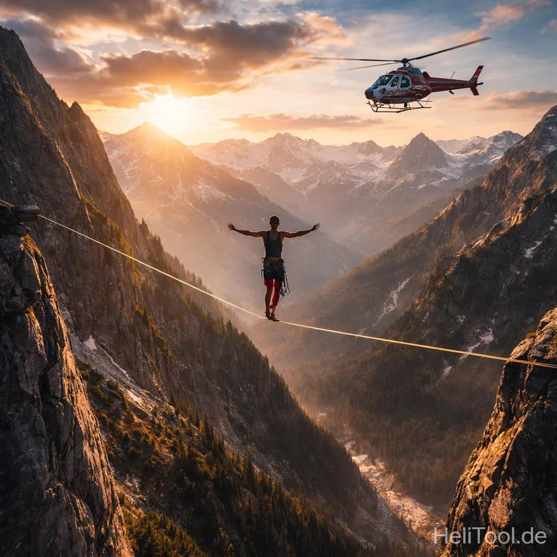
World-record slacklines have stretched over 2 km long and hundreds of meters above ground — often in dramatic outdoor locations such as alpine valleys or national parks.
Slacklining is more than a hobby — it’s a community. Enthusiasts share locations, techniques, gear tips, and stories on forums and social platforms to grow and support the sport.
🚁 The Hidden Risk: Slacklines and Low-Flying Helicopters
While stunning and often remote, slackline locations can intersect with helicopter flight paths — especially in mountainous and canyon terrain where helicopters operate at low altitude during rescue missions, sightseeing flights, law enforcement activity, and training.
This risk was tragically underscored in early 2026 when a helicopter struck a highline/slackline suspended in a canyon near Superior, Arizona, killing all four people aboard.
Preliminary investigations by the United States’ National Transportation Safety Board (NTSB) confirmed slackline material embedded in the helicopter’s structure, and eyewitnesses reported seeing the aircraft hit a line hundreds of feet above ground.
Although the slackline was reportedly marked and a NOTAM (Notice to Airmen) issued, the tragic event revealed gaps in how aerial obstacles — especially temporary or recreational installations — are communicated to pilots.
🗺️ Where Slackliners Practice
Slacklines appear in many environments globally:
- Urban parks and green spaces — community slacklining for locals and beginners
- Forest and wilderness areas — lines between trees or natural anchor points
- Canyons and mountainous regions — highlines spanning impressive geographic features
- Near trails and alpine routes — offering spectacular views and challenging lines
In mountain regions such as the European Alps, slackliners take advantage of rock faces and ridges — often at elevations where helicopters may also operate for avalanche control, rescue missions, or environmental monitoring. This intersection makes awareness and active communication even more critical.
🛠️ Slackliners Can Help Improve Flight Safety
At HeliTool, we believe the slackline community can play an important role in aviation safety — by publishing slackline locations and events on our open platform:
👉 Publish your slackline events and locations here:
Once registered for free, slackliners can add details such as line coordinates, planned setup dates, altitude, and terrain type. This helps improve situational awareness for low-flying crews and supports safer planning for both pilots and slackliners.
By integrating slackline data into aviation obstacle maps, we can:
✔ Reduce unknown aerial hazards for helicopter crews
✔ Support better pre-flight planning and obstacle avoidance
✔ Foster collaboration between outdoor recreationists and aviation communities
📣 Join the Movement!
Slacklining should be fun — not dangerous for others. By contributing your slackline information to HeliTool, you help build a safer low-flight ecosystem, especially in geographies where helicopters are active — like the Alps, canyons, and wilderness regions worldwide.
💡 Whether you’re highlining in the Alps or rigging in a local canyon, share it — and let’s make the skies safer together!

Comments (0)
No comments yet. Be the first to comment!